
Wana Pariq topographic map
Interactive map
Click on the map to display elevation.
About this map
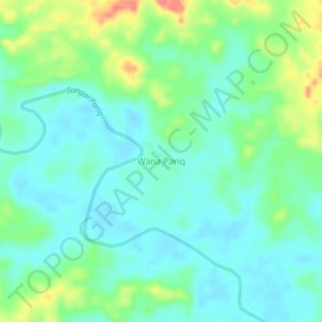
Name: Wana Pariq topographic map, elevation, terrain.
Location: Wana Pariq, Kalimantan oriental, Indonésie (0.26124 115.50989 0.30124 115.54989)
Average elevation: 29 m
Minimum elevation: 10 m
Maximum elevation: 75 m
Other topographic maps
Click on a map to view its topography, its elevation and its terrain.
Gunung Samarinda
Indonésie > Kalimantan oriental > Balikpapan
Gunung Samarinda, Balikpapan Utara, Balikpapan, Kalimantan oriental, Kalimantan, 76125, Indonésie
Average elevation: 25 m
Nusantara
Indonésie > Kalimantan oriental > Nusantara
Nusantara, Kalimantan oriental, Indonésie
Average elevation: 62 m
Klandasan Ilir
Indonésie > Kalimantan oriental > Balikpapan
Klandasan Ilir, Balikpapan, Kalimantan oriental, 76121, Indonésie
Average elevation: 17 m
Random
Indonésie > Kalimantan oriental > Paser
Random, Paser, Kalimantan oriental, Indonésie
Average elevation: 11 m
Tapis
Indonésie > Kalimantan oriental > Paser
Tapis, Paser, Kalimantan oriental, 76251, Indonésie
Average elevation: 16 m
Prapatan
Indonésie > Kalimantan oriental > Prapatan
Prapatan, Kalimantan oriental, 76112, Indonésie
Average elevation: 15 m