
Underwood topographic map
Interactive map
Click on the map to display elevation.
About this map
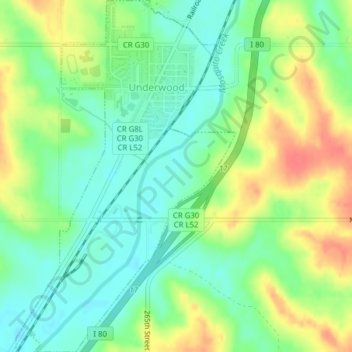
Name: Underwood topographic map, elevation, terrain.
Location: Underwood, Pottawattamie County, Iowa, United States (41.36528 -95.69440 41.39443 -95.67008)
Average elevation: 339 m
Minimum elevation: 316 m
Maximum elevation: 372 m
Other topographic maps
Click on a map to view its topography, its elevation and its terrain.
Carson
United States > Iowa > Pottawattamie County
Carson, Pottawattamie County, Iowa, 51525, United States
Average elevation: 341 m
Hitchcock Nature Center
United States > Iowa > Pottawattamie County
Hitchcock Nature Center, Pottawattamie County, Iowa, United States
Average elevation: 338 m
Avoca
United States > Iowa > Pottawattamie County > Avoca
Avoca, Pottawattamie County, Iowa, 51521, United States
Average elevation: 353 m