
Soissons topographic map
Interactive map
Click on the map to display elevation.
About this map
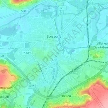
Name: Soissons topographic map, elevation, terrain.
Average elevation: 59 m
Minimum elevation: 37 m
Maximum elevation: 158 m
Other topographic maps
Click on a map to view its topography, its elevation and its terrain.
Saint-Quentin
France > Hauts-de-France > Aisne > Saint-Quentin > Saint-Quentin
Average elevation: 99 m