
Palestine topographic map
Interactive map
Click on the map to display elevation.
About this map
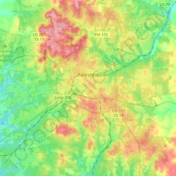
Name: Palestine topographic map, elevation, terrain.
Location: Palestine, Anderson County, Texas, United States (31.69527 -95.72426 31.80843 -95.56776)
Average elevation: 136 m
Minimum elevation: 85 m
Maximum elevation: 204 m
About 40% of the content from the 2003 Space Shuttle Columbia disaster was recovered. seven astronauts were killed in the accident.[19] Debris from Columbia was found in and outside Palestine and other East Texas towns.[20][21] Palestine's NASA Columbia Scientific Balloon Facility (renamed in honor of the shuttle crew), has flown 1,700 high-altitude balloons for universities and research agencies.
Other topographic maps
Click on a map to view its topography, its elevation and its terrain.
Daly Mountain
United States > Texas > Anderson County > Neches
Daly Mountain, Neches, Anderson County, Texas, 75779, United States
Average elevation: 128 m
Fosterville
United States > Texas > Anderson County
Fosterville, Anderson County, Texas, United States
Average elevation: 133 m
Yard
United States > Texas > Anderson County
Yard, Anderson County, Texas, United States
Average elevation: 78 m