
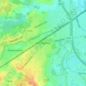
West Byfleet topographic map
Interactive map
Click on the map to display elevation.
About this map
Name: West Byfleet topographic map, elevation, terrain.
Average elevation: 26 m
Minimum elevation: 13 m
Maximum elevation: 52 m
The surface undulates gently from the west to the east, where West Byfleet's land is drained in the parish of Byfleet itself by the River Wey. Soil ranges from sandy acidic soil in the west to more alluvial soil in the east, underlain by a mixture of gravel and clay. Elevations range from 18m Above Ordnance Datum to 33m.
Other topographic maps
Click on a map to view its topography, its elevation and its terrain.
Brookwood Country Park
United Kingdom > England > Surrey > Woking > Knaphill
Brookwood Country Park, Hermitage Woods, Knaphill, Woking, Surrey, England, United Kingdom
Average elevation: 47 m
Old Woking
United Kingdom > England > Surrey > Woking
Old Woking, Woking, Surrey, England, GU22 9HD, United Kingdom
Average elevation: 31 m
Brookwood
United Kingdom > England > Surrey > Woking
Brookwood, Woking, Surrey, England, GU24 0HG, United Kingdom
Average elevation: 48 m
Sutton Green
United Kingdom > England > Surrey > Woking
Sutton Green, Woking, Surrey, England, GU4 7QD, United Kingdom
Average elevation: 32 m
Mayford
United Kingdom > England > Surrey > Woking
Mayford, Woking, Surrey, England, GU22 0NL, United Kingdom
Average elevation: 35 m
Knaphill
United Kingdom > England > Surrey > Woking
Knaphill, Woking, Surrey, England, GU21 2DG, United Kingdom
Average elevation: 43 m
Horsell Common
United Kingdom > England > Surrey > Woking > Horsell > Durnford Farm
Horsell Common, Durnford Farm, Horsell, Woking, Surrey, South East England, England, United Kingdom
Average elevation: 29 m
Byfleet
United Kingdom > England > Surrey > Woking
Byfleet, Woking, Surrey, England, KT14 7PN, United Kingdom
Average elevation: 27 m
Horsell
United Kingdom > England > Surrey > Woking
Horsell, Woking, Surrey, England, GU21 4QZ, United Kingdom
Average elevation: 32 m