
Presidio County topographic map
Interactive map
Click on the map to display elevation.
About this map
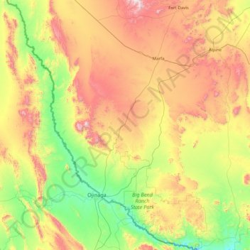
Name: Presidio County topographic map, elevation, terrain.
Location: Presidio County, Texas, United States (29.25837 -104.98075 30.62922 -103.79246)
Average elevation: 1,255 m
Minimum elevation: 716 m
Maximum elevation: 2,348 m
Geographically, Presidio County comprises 3,857 square miles (9,990 km2) of contrasting topography, geology, and vegetation. In the north and west, clay and sandy loam cover the rolling plains known as the Marfa Plateau and the Highland Country, providing good ranges of grama grasses for the widely acclaimed Highland Herefords. In the central, far western, and southeastern areas of the county, some of the highest mountain ranges in Texas are found. These peaks are formed of volcanic rock and covered with loose surface rubble. They support desert shrubs and cacti and dominate a landscape of rugged canyons and numerous springs. The spring-fed Capote Falls, with a drop of 175 feet (53 m), the highest in Texas, is located in western Presidio County. In the southern and western parts of the county, the volcanic cliffs of the Candelaria Rimrock (also called the Sierra Vieja) rise perpendicular and run parallel to the river, separating the highland prairies from the desert floor hundreds of feet below them. The gravel pediment, which allows only the growth of desert shrubs and cacti, extends from the Rimrock to the flood plain of the river. Along the river, irrigation allows the farming of vegetables, grains, and cotton. No permanent streams exist in the county, although many arroyos become raging torrents during heavy rainfalls. Major ones are Alamito Creek, Cibolo Creek, Capote Creek, and Pinto Canyon. San Esteban Dam was built across Alamito Creek and on the site of a historic spring-fed tinaja in 1911 as an irrigation and land-promotion project. Altitudes in the county vary from 2,518 to 7,728 feet (767 to 2,355 m) above sea level. Temperatures, moderated by the mountains, vary from 33 °F (1 °C) in January to 100 °F (38 °C) in July. Average rainfall is 12 inches (300 mm) per year, mainly in June, July, and August. The growing season extends for 238 days. Natural resources under production in 1982 were perlite, crushed rhyolite, sand, and gravel. Silver mining contributed greatly to the economy of the county from the 1880s to the 1940s. Presidio County has no oil or gas production.
Other topographic maps
Click on a map to view its topography, its elevation and its terrain.
Houston
United States > Texas > Harris County
Houston, Harris County, Texas, United States
Average elevation: 25 m
Fort Worth
United States > Texas > Tarrant County
Fort Worth, Tarrant County, Texas, United States
Average elevation: 212 m
College Station
United States > Texas > Brazos County
College Station, Brazos County, Texas, United States
Average elevation: 87 m
Corpus Christi
United States > Texas > Nueces County
Corpus Christi, Nueces County, Texas, United States
Average elevation: 8 m
San Antonio
United States > Texas > Bexar County > San Antonio
San Antonio, Bexar County, Texas, 78205, United States
Average elevation: 218 m
Nadeau
United States > Texas > Galveston County > Texas City
Nadeau, Texas City, Galveston County, Texas, 77590, United States
Average elevation: 4 m
The Woodlands
United States > Texas > Montgomery County
The Woodlands, Montgomery County, Texas, United States
Average elevation: 47 m
Aurora
United States > Texas > Wise County
Aurora, Wise County, Texas, United States
Average elevation: 228 m
Memorial Park
United States > Texas > Aransas County > Rockport
Memorial Park, Rockport, Aransas County, Texas, 78382, United States
Average elevation: 9 m
Montgomery County
Montgomery County, Texas, United States
Average elevation: 69 m
Tomball
United States > Texas > Harris County
Tomball, Harris County, Texas, 77375, United States
Average elevation: 52 m
Brownsville
United States > Texas > Cameron County
Brownsville, Cameron County, Texas, United States
Average elevation: 9 m
Texas City
United States > Texas > Galveston County
Texas City, Galveston County, Texas, United States
Average elevation: 2 m
Georgetown
United States > Texas > Georgetown
Georgetown, Williamson County, Texas, United States
Average elevation: 219 m
Midland
United States > Texas > Midland County
Midland, Midland County, Texas, United States
Average elevation: 855 m
Rockwall
United States > Texas > Rockwall County > Rockwall
Rockwall, Rockwall County, Texas, United States
Average elevation: 156 m
Texarkana
United States > Texas > Bowie County
Texarkana, Bowie County, Texas, United States
Average elevation: 99 m
Bruceville-Eddy
United States > Texas > McLennan County
Bruceville-Eddy, McLennan County, Texas, 76524, United States
Average elevation: 198 m
Converse
United States > Texas > Bexar County
Converse, Bexar County, Texas, 78109, United States
Average elevation: 223 m
Blum
United States > Texas > Hill County
Blum, Hill County, Texas, United States
Average elevation: 190 m
Vidor
United States > Texas > Orange County
Vidor, Orange County, Texas, 77662, United States
Average elevation: 5 m
Irving
United States > Texas > Dallas County
Irving, Dallas County, Texas, United States
Average elevation: 149 m
Ravenna
United States > Texas > Fannin County
Ravenna, Fannin County, Texas, United States
Average elevation: 179 m
Prosper
United States > Texas > Collin County
Prosper, Collin County, Texas, 75078, United States
Average elevation: 209 m
San Juan South Estates Colonia
United States > Texas > Hidalgo County > San Juan
San Juan South Estates Colonia, San Juan, Hidalgo County, Texas, 78589, United States
Average elevation: 34 m
Gorman
United States > Texas > Eastland County
Gorman, Eastland County, Texas, 76454, United States
Average elevation: 440 m
Buenos
United States > Texas > Garza County
Buenos, Garza County, Texas, United States
Average elevation: 876 m
Alamo Heights
United States > Texas > Bexar County
Alamo Heights, Bexar County, Texas, United States
Average elevation: 232 m
Brandon
United States > Texas > Hill County
Brandon, Hill County, Texas, 76628, United States
Average elevation: 188 m
Mount Lucas
United States > Texas > Travis County > Austin
Mount Lucas, Austin, Travis County, Texas, 78731, United States
Average elevation: 196 m
Gordonville
United States > Texas > Grayson County
Gordonville, Grayson County, Texas, United States
Average elevation: 211 m
Marshall
United States > Texas > Harrison County
Marshall, Harrison County, Texas, United States
Average elevation: 112 m
Security
United States > Texas > Montgomery County
Security, Montgomery County, Texas, United States
Average elevation: 53 m
Fredericksburg
United States > Texas > Gillespie County
Fredericksburg, Gillespie County, Texas, United States
Average elevation: 526 m
Saginaw
United States > Texas > Tarrant County
Saginaw, Tarrant County, Texas, United States
Average elevation: 216 m
Eagle Mountain Lake
United States > Texas > Tarrant County > Pelican Bay
Eagle Mountain Lake, Pelican Bay, Tarrant County, Texas, United States
Average elevation: 228 m
Dallas
United States > Texas > Dallas County
Dallas, Dallas County, Texas, United States
Average elevation: 160 m
Seguin
United States > Texas > Guadalupe County
Seguin, Guadalupe County, Texas, United States
Average elevation: 172 m