
Make a donation
Gear up for your next adventure:
As an Amazon Associate, this site earns from qualifying purchases at no extra cost to you.
Lefkada topographic map
Click on the map to display elevation.
Make a donation
Gear up for your next adventure:
As an Amazon Associate, this site earns from qualifying purchases at no extra cost to you.
About this map
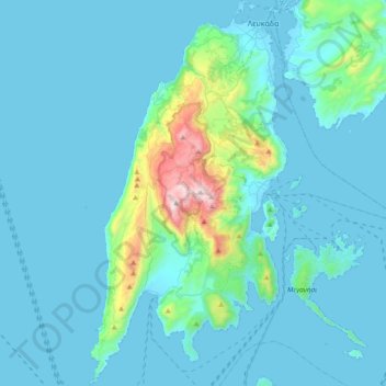
Name: Lefkada topographic map, elevation, terrain.
Average elevation: 111 m
Minimum elevation: -2 m
Maximum elevation: 1,160 m
Make a donation
Gear up for your next adventure:
As an Amazon Associate, this site earns from qualifying purchases at no extra cost to you.
Other topographic maps
Click on a map to view its topography, its elevation and its terrain.
Athani
Greece > Peloponnese, Western Greece and the Ionian > Lefkada Regional Unit > Municipal Unit of Apollonioi
Average elevation: 325 m
Katomeri
Greece > Peloponnese, Western Greece and the Ionian > Lefkada Regional Unit
Average elevation: 24 m
Gyra (Anna)
Greece > Peloponnese, Western Greece and the Ionian > Lefkada Regional Unit > Municipal Unit of Lefkada
Average elevation: 0 m