
Gevelsberg topographic map
Interactive map
Click on the map to display elevation.
Gevelsberg
The town lies in the valley of the river Ennepe in the Süder Uplands, which is part of the Rhenish Massif. Gevelsberg lies about halfway between Wuppertal and Hagen, and is part of the industrial Ruhr Region. The lowest elevation is the Ennepe river at Vogelsang (132 m or 433 ft) and highest is the Hageböllinger Kopf (336 m or 1,102 ft). Its east-to-west length is 7.1 kilometres (4+3⁄8 miles) and the north to south length is 7.15 km (4+7⁄16 mi).
About this map
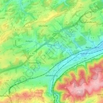
Name: Gevelsberg topographic map, elevation, terrain.
Average elevation: 228 m
Minimum elevation: 136 m
Maximum elevation: 377 m
Other topographic maps
Click on a map to view its topography, its elevation and its terrain.
Oberbredenscheid
Germany > North Rhine-Westphalia > Ennepe-Ruhr-Kreis > Hattingen > Oberbredenscheid
Average elevation: 153 m