
Westmoreland topographic map
Interactive map
Click on the map to display elevation.
About this map
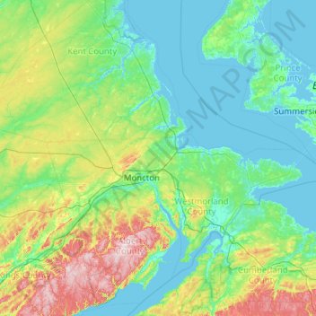
Name: Westmoreland topographic map, elevation, terrain.
Average elevation: 63 m
Minimum elevation: -4 m
Maximum elevation: 417 m
Other topographic maps
Click on a map to view its topography, its elevation and its terrain.
Deer Island
Canadá > Nuevo Brunswick > Deer Island
Deer Island, West Isles Parish, Charlotte County, Nuevo Brunswick, E5V 1W2, Canadá
Average elevation: 9 m