
Mönchengladbach topographic map
Interactive map
Click on the map to display elevation.
About this map
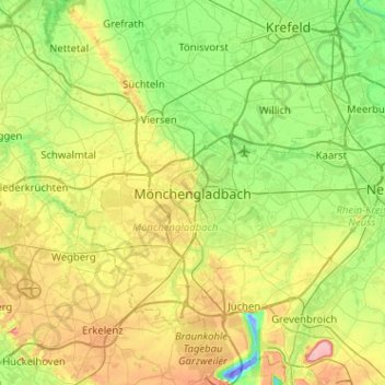
Name: Mönchengladbach topographic map, elevation, terrain.
Average elevation: 59 m
Minimum elevation: -47 m
Maximum elevation: 181 m
Other topographic maps
Click on a map to view its topography, its elevation and its terrain.
Wickrath-Mitte
Germany > North Rhine-Westphalia > Mönchengladbach
Wickrath-Mitte, West, Mönchengladbach, North Rhine-Westphalia, 41189, Germany
Average elevation: 73 m