
Kauai topographic map
Interactive map
Click on the map to display elevation.
About this map
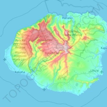
Name: Kauai topographic map, elevation, terrain.
Location: Kauai, Kauaʻi County, Hawaii, United States (21.86822 -159.78783 22.23271 -159.29232)
Average elevation: 216 m
Minimum elevation: 0 m
Maximum elevation: 1,568 m
Kauaʻi's climate is tropical, with generally humid and stable conditions year-round, although weather phenomena and infrequent storms have caused instances of extreme weather. At the lower elevations, the annual precipitation varies from an average of about 50 in (130 cm) on the windward (northeastern) shore to less than 20 in (51 cm) on the (southwestern) leeward side of the island. The average temperature in Lihu'e, the county seat, ranges from 78 °F (26 °C) in February to 85 °F (29 °C) in August and September. Kauaʻi's mountainous regions offer cooler temperatures and provide a pleasant contrast to the warm coastal areas. At the Kōkeʻe state park, 3,200–4,200 ft (980–1,280 m) ASL, day temperatures vary from an average of 45 °F (7 °C) in January to 68 °F (20 °C) in July. In the winter, temperatures have been known to drop down to the 30s and 40s at Kōkeʻe state park, which holds an unofficial record low of 29 °F (−2 °C) recorded in February 1986 at Kanaloahuluhulu Meadow.
Other topographic maps
Click on a map to view its topography, its elevation and its terrain.
Waiokapua Bay
United States > Hawaii > Kauaʻi County
Waiokapua Bay, Kauaʻi County, Hawaii, United States
Average elevation: 3 m
Na Pali Coast State Park
United States > Hawaii > Kauaʻi County
Na Pali Coast State Park, Kauaʻi County, Hawaii, United States
Average elevation: 467 m
Wailua Homesteads Park
United States > Hawaii > Kauaʻi County > Wailua
Wailua Homesteads Park, Wailua House Lots, Wailua, Kauaʻi County, Hawaii, United States
Average elevation: 48 m
Alakaʻi Wilderness Preserve
United States > Hawaii > Kauaʻi County
Alakaʻi Wilderness Preserve, Kauaʻi County, Hawaii, United States
Average elevation: 1,028 m
Waimea Canyon State Park
United States > Hawaii > Kauaʻi County
Waimea Canyon State Park, Kauaʻi County, Hawaii, United States
Average elevation: 695 m
Wailua
United States > Hawaii > Kauaʻi County > Wailua
Wailua, Kauaʻi County, Hawaii, United States
Average elevation: 39 m
Waimea
United States > Hawaii > Kauaʻi County > Waimea
Waimea, Kauaʻi County, Hawaii, United States
Average elevation: 59 m
Kalaheo
United States > Hawaii > Kauaʻi County > Kalaheo
Kalaheo, Kauaʻi County, Hawaii, 96741, United States
Average elevation: 183 m
Kapaa
United States > Hawaii > Kauaʻi County > Kapaa
Kapaa, Kauaʻi County, Hawaii, United States
Average elevation: 96 m