
Madison County topographic map
Interactive map
Click on the map to display elevation.
About this map
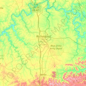
Name: Madison County topographic map, elevation, terrain.
Location: Madison County, Kentucky, United States (37.51528 -84.52564 37.91748 -84.07387)
Average elevation: 277 m
Minimum elevation: 165 m
Maximum elevation: 506 m
Other topographic maps
Click on a map to view its topography, its elevation and its terrain.
Indian Fort Mountain
United States > Kentucky > Madison County
Indian Fort Mountain, Madison County, Kentucky, 40403, United States
Average elevation: 333 m
Richmond
United States > Kentucky > Madison County > Richmond
Richmond, Madison County, Kentucky, 40475, United States
Average elevation: 267 m