
Make a donation
King Sabata Dalindyebo Local Municipality topographic map
Interactive map
Click on the map to display elevation.


About this map
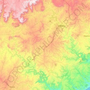
Name: King Sabata Dalindyebo Local Municipality topographic map, elevation, terrain.
Average elevation: 742 m
Minimum elevation: 0 m
Maximum elevation: 1,722 m
Other topographic maps
Click on a map to view its topography, its elevation and its terrain.
Efeta
South Africa > Eastern Cape > O.R. Tambo District Municipality > King Sabata Dalindyebo Local Municipality
Average elevation: 709 m
Tina Falls
South Africa > Eastern Cape > O.R. Tambo District Municipality > Mhlontlo Local Municipality
Average elevation: 565 m
Coffee Bay
South Africa > Eastern Cape > O.R. Tambo District Municipality > King Sabata Dalindyebo Local Municipality
Average elevation: 40 m
KwaBityi
South Africa > Eastern Cape > O.R. Tambo District Municipality > King Sabata Dalindyebo Local Municipality
Average elevation: 808 m