
Sauerland topographic map
Interactive map
Click on the map to display elevation.
Sauerland
To the west the hills continue into the Bergisches Land, to the south into the Siegerland, and to the north-east into the Teutoburg Forest. The major rivers of the Sauerland are the Ruhr and the Lenne. Several artificial lakes were created on the smaller rivers by building dams to store water for the nearby Ruhr area, the biggest reservoirs being the Möhne and Bigge. Although the highest elevation of the Sauerland is the Langenberg (843 m) near Olsberg, the much more renowned summit, which is well known for the nearby skiing facilities, its weather station and observation tower, is the slightly lower Kahler Asten (842 m) near Winterberg. Both Langenberg and Kahler Asten are peaks in the Rothaargebirge mountains.
About this map
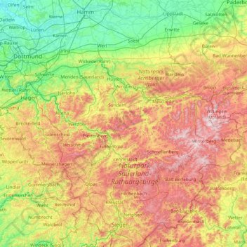
Name: Sauerland topographic map, elevation, terrain.
Location: Sauerland, North Rhine-Westphalia, Germany (50.92129 7.42669 51.59645 8.92098)
Average elevation: 316 m
Minimum elevation: 41 m
Maximum elevation: 844 m
Other topographic maps
Click on a map to view its topography, its elevation and its terrain.
Aachen
Germany > North Rhine-Westphalia > Städteregion Aachen
The maximum dimensions of the city's territory are 21.6 km (13+3⁄8 mi) from north to south, and 17.2 km (10+3⁄4 mi) from east to west. The city limits are 87.7 km (54+1⁄2 mi) long, of which 23.8 km (14+3⁄4 mi) border Belgium and 21.8 km (13+1⁄2 mi) the Netherlands. The highest point in Aachen,…
Average elevation: 225 m
Dorfbauernschaft
Germany > North Rhine-Westphalia > Kreis Steinfurt > Emsdetten
Average elevation: 46 m
Moßberg
Germany > North Rhine-Westphalia > Märkischer Kreis > Menden (Sauerland)
Average elevation: 220 m
53639
Germany > North Rhine-Westphalia > Rhein-Sieg-Kreis > Königswinter > Bellinghausen > Bellinghauserhohn
Average elevation: 166 m
Plettenberg
Germany > North Rhine-Westphalia > Märkischer Kreis
Plettenberg is located to the west of the Sauerland hills. The highest elevation of the town area is in the Ebbe Mountains with 663 m above sea level, the lowest elevation with 194 m near Teindeln [de]. The town is spread out between the four valleys of the rivers Lenne, Else, Oester [arz; ceb; cv; de; zh] and…
Average elevation: 378 m
Warstein
Germany > North Rhine-Westphalia > Kreis Soest
Warstein is located north of the Arnsberger Wald (forest), at a brook called Wäster. The area south of the city is mostly forested; the lightly forested Haarstrang mountain is to the north. The river Möhne flows between these two areas. The highest elevation is 581 m (1,906 ft) in the south of the city near…
Average elevation: 373 m
Münster
Germany > North Rhine-Westphalia
Münster is situated on the river Aa, approximately 15 kilometres (9 miles) south of its confluence with the Ems in the so-called Westphalian Bight, a landscape studded with dispersed settlements and farms – the "Münsterland". The Wolstonian sediments of the mountain ridge called "Münsterländer…
Average elevation: 61 m
Bocholt
Germany > North Rhine-Westphalia > Kreis Borken
The climate in the region of Bocholt and West Münsterland is temperate with distinct maritime influences, with very mild winters in comparison to other German regions because of the proximity to the ocean and the low elevation. Summers are moderately warm. The average temperature in January is 2.7 °C (37…
Average elevation: 31 m
Gellinghausen
Germany > North Rhine-Westphalia > Hochsauerlandkreis > Schmallenberg > Westernbödefeld
Average elevation: 565 m
Radevormwald
Germany > North Rhine-Westphalia > Oberbergischer Kreis
Radevormwald means "clearing in front of the wood". The town's older name, Rotha, also means "clearing". The clearing, at an altitude of more than 400 metres, is thought to have been made to help defend against raiding Saxons in prehistoric times.
Average elevation: 327 m
Bochum
Germany > North Rhine-Westphalia
The city lies on the low rolling hills of Bochum land ridge (Bochumer Landrücken), part of the Ruhrhöhen (highest elevations) between the Ruhr and Emscher rivers at the border of the southern and northern Ruhr coal region. The highest point of the city is at Kemnader Straße (Kemnader Street) in Stiepel at…
Average elevation: 99 m
Auf dem Wengel
Germany > North Rhine-Westphalia > Kreis Heinsberg > Wegberg > Büch
Average elevation: 79 m
Hagen
Germany > North Rhine-Westphalia
42 per cent of Hagen's municipal area consists of forest. The four rivers in Hagen stretch over a length of 52.2 km: Ruhr 11.5 km, Lenne 13.1 km, Volme 21.3 km and Ennepe 6.3 km. The difference in altitude from the lowest point on the Ruhr near Vorhalle (86 metres above sea level) to the highest point east of…
Average elevation: 230 m
Minden
Germany > North Rhine-Westphalia > Kreis Minden-Lübbecke
The Weser leaves the Minden area at its lowest part in the quarter of Leteln, at 40 metres (131 feet), while the highest part is the top of Häverstädter Berg with 272 metres (892 feet), at the edge of the Wiehen Hills in the quarter of Haddenhausen. The altitude of the town is given officially as 42.2 metres…
Average elevation: 60 m
Remlingrade
Germany > North Rhine-Westphalia > Oberbergischer Kreis > Radevormwald
Average elevation: 306 m
Neuastenberg
Germany > North Rhine-Westphalia > Hochsauerlandkreis > Winterberg
Average elevation: 685 m
45663
Germany > North Rhine-Westphalia > Kreis Recklinghausen > Recklinghausen
Average elevation: 57 m
Schevenhütte
Germany > North Rhine-Westphalia > Städteregion Aachen > Stolberg
Average elevation: 244 m
Lenneplätze
Germany > North Rhine-Westphalia > Hochsauerlandkreis > Winterberg > Neuastenberg
Average elevation: 699 m
Holtwick
Germany > North Rhine-Westphalia > Kreis Recklinghausen > Haltern am See
Average elevation: 89 m
Münster
Germany > North Rhine-Westphalia
Münster is situated on the river Aa, approximately 15 kilometres (9 miles) south of its confluence with the Ems in the so-called Westphalian Bight, a landscape studded with dispersed settlements and farms – the "Münsterland". The Wolstonian sediments of the mountain ridge called "Münsterländer…
Average elevation: 61 m