
Prescott and Russell Counties topographic map
Interactive map
Click on the map to display elevation.
About this map
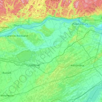
Name: Prescott and Russell Counties topographic map, elevation, terrain.
Average elevation: 98 m
Minimum elevation: 34 m
Maximum elevation: 432 m
Other topographic maps
Click on a map to view its topography, its elevation and its terrain.
Rockland
Canada > Ontario > Prescott and Russell Counties
Rockland, Clarence-Rockland, Prescott and Russell Counties, Eastern Ontario, Ontario, K4K 1A0, Canada
Average elevation: 59 m
Alfred and Plantagenet
Canada > Ontario > Prescott and Russell Counties
Alfred and Plantagenet, Prescott and Russell Counties, Eastern Ontario, Ontario, Canada
Average elevation: 71 m
Champlain
Canada > Ontario > Prescott and Russell Counties
Champlain, Prescott and Russell Counties, Eastern Ontario, Ontario, Canada
Average elevation: 68 m
The Nation
Canada > Ontario > Prescott and Russell Counties
The Nation, Prescott and Russell Counties, Eastern Ontario, Ontario, Canada
Average elevation: 72 m
Hawkesbury
Canada > Ontario > Prescott and Russell Counties
Hawkesbury, Prescott and Russell Counties, Eastern Ontario, Ontario, Canada
Average elevation: 52 m