
Mittenwald topographic map
Interactive map
Click on the map to display elevation.
About this map
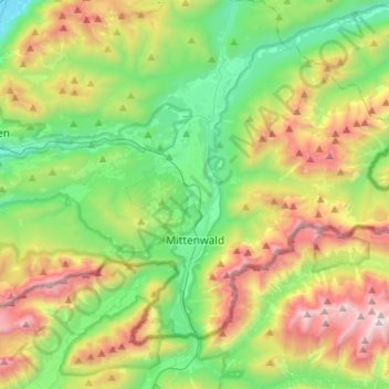
Name: Mittenwald topographic map, elevation, terrain.
Location: Mittenwald, Landkreis Garmisch-Partenkirchen, Bavaria, Germany (47.39511 11.15671 47.53197 11.42143)
Average elevation: 1,347 m
Minimum elevation: 649 m
Maximum elevation: 2,645 m
Other topographic maps
Click on a map to view its topography, its elevation and its terrain.
Schachen
Germany > Bavaria > Landkreis Garmisch-Partenkirchen > Garmisch-Partenkirchen
Average elevation: 1,636 m
Partnach Gorge
Germany > Bavaria > Landkreis Garmisch-Partenkirchen > Garmisch-Partenkirchen > Vordergraseck
Average elevation: 1,004 m
Zugspitze
Germany > Bavaria > Landkreis Garmisch-Partenkirchen > Grainau
The mountain rises eleven kilometres southwest of Garmisch-Partenkirchen and just under six kilometres east of Ehrwald. The border between Germany and Austria runs over the west summit; thus the Zugspitze massif belongs to the German state of Bavaria and the Austrian state of Tyrol. The municipalities…
Average elevation: 2,300 m
Martina-Glagow-Park
Germany > Bavaria > Landkreis Garmisch-Partenkirchen > Mittenwald
Average elevation: 1,025 m