
Grand Case topographic map
Interactive map
Click on the map to display elevation.
About this map
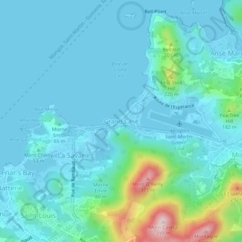
Name: Grand Case topographic map, elevation, terrain.
Location: Grand Case, Saint Martin (France), 97150, France (18.08053 -63.07760 18.12053 -63.03760)
Average elevation: 57 m
Minimum elevation: 0 m
Maximum elevation: 378 m
Other topographic maps
Click on a map to view its topography, its elevation and its terrain.
Marigot
France > Saint Martin (France) > Marigot
Marigot, Saint Martin (France), 97150, France
Average elevation: 44 m
Rambaud
France > Saint Martin (France)
Rambaud, Saint Martin (France), 97150, France
Average elevation: 95 m