
District of Rožňava topographic map
Interactive map
Click on the map to display elevation.
About this map
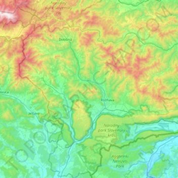
Name: District of Rožňava topographic map, elevation, terrain.
Average elevation: 597 m
Minimum elevation: 147 m
Maximum elevation: 1,931 m
Other topographic maps
Click on a map to view its topography, its elevation and its terrain.
Ochtiná
Slovakia > Region of Košice > District of Rožňava > Ochtiná
Ochtiná, District of Rožňava, Region of Košice, Eastern Slovakia, 049 35, Slovakia
Average elevation: 402 m
Čoltovo
Slovakia > Region of Košice > District of Rožňava
Čoltovo, District of Rožňava, Region of Košice, Eastern Slovakia, 980 46, Slovakia
Average elevation: 285 m
Národný park Slovenský kras
Slovakia > Region of Košice > District of Rožňava
Národný park Slovenský kras, 16, Slavec, District of Rožňava, Region of Košice, Eastern Slovakia, 049 11, Slovakia
Average elevation: 449 m