
Elbrus District topographic map
Interactive map
Click on the map to display elevation.
About this map
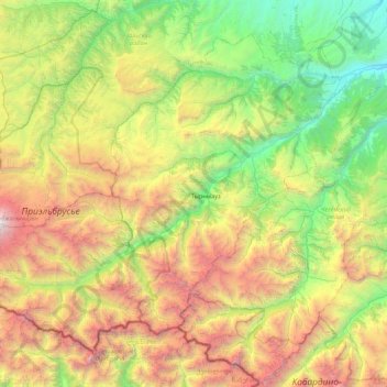
Name: Elbrus District topographic map, elevation, terrain.
Average elevation: 2,306 m
Minimum elevation: 652 m
Maximum elevation: 5,485 m
Other topographic maps
Click on a map to view its topography, its elevation and its terrain.
Mount Elbrus (East Summit)
Russia > Kabardino-Balkaria > Elbrus District
As Elbrus is located in the Northern Hemisphere, the summer period takes place from June to mid-September, with an average of 50% of sunny days favorable to the ascent of the summit. However, the winds, dominated by westerly air masses, can turn violent and temperatures drop very quickly. Above 4000 meters…
Average elevation: 5,160 m