
Colchester County topographic map
Interactive map
Click on the map to display elevation.
About this map
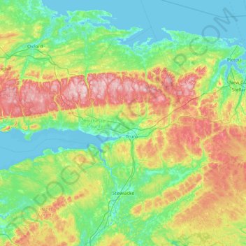
Name: Colchester County topographic map, elevation, terrain.
Location: Colchester County, Nova Scotia, Canada (45.02917 -64.13345 45.80991 -62.71213)
Average elevation: 91 m
Minimum elevation: -4 m
Maximum elevation: 361 m
Other topographic maps
Click on a map to view its topography, its elevation and its terrain.
Flat Rock
Canada > Nova Scotia > Municipality of the County of Richmond > Grand River
Average elevation: 5 m
Little Three Cornered Lake
Canada > Nova Scotia > Guysborough District Municipality > Ogden
Average elevation: 120 m
South Harbour
Canada > Nova Scotia > Municipality of Victoria County > South Harbour
Average elevation: 22 m
Fox Cove North Cape
Canada > Nova Scotia > Municipality of the County of Richmond > Framboise Intervale
Average elevation: 6 m
Port Mouton Island
Canada > Nova Scotia > Queens County > South West Port Mouton
Average elevation: 27 m
Wentworth Provincial Park
Canada > Nova Scotia > Municipality of the County of Cumberland > Wentworth Station
Average elevation: 81 m
Old Fort Point
Canada > Nova Scotia > Municipality of Victoria County > Englishtown
Average elevation: 32 m
Carters Beach
Canada > Nova Scotia > Guysborough District Municipality > Hadleyville
Average elevation: 7 m
Mull River
Canada > Nova Scotia > Municipality of the County of Inverness > Mabou
Average elevation: 83 m
Kidston Island Lighthouse
Canada > Nova Scotia > Municipality of Victoria County > Baddeck
Average elevation: 11 m
Margaret Boone Memorial Park
Canada > Nova Scotia > Cape Breton Regional Municipality > Dominion
Average elevation: 13 m