
Noun topographic map
Interactive map
Click on the map to display elevation.
About this map
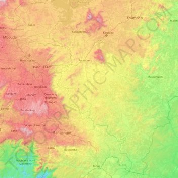
Name: Noun topographic map, elevation, terrain.
Location: Noun, Ndé, West, Cameroon (4.90781 10.45625 5.81807 11.10151)
Average elevation: 1,043 m
Minimum elevation: 266 m
Maximum elevation: 2,216 m
Other topographic maps
Click on a map to view its topography, its elevation and its terrain.
Batchingou
Cameroon > West > Ndé > Bangangté
Batchingou, Bangangté, Ndé, West, Cameroon
Average elevation: 1,436 m
Bangang Fokam
Cameroon > West > Ndé > Bangangté
Bangang Fokam, Bangangté, Ndé, West, Cameroon
Average elevation: 1,341 m
Bandenkop
Cameroon > West > Hauts-Plateaux > Bangou
Bandenkop, Bangou, Hauts-Plateaux, West, Cameroon
Average elevation: 1,765 m
Foreke Dschang
Cameroon > West > Menoua > Dschang
Foreke Dschang, Dschang, Menoua, West, Cameroon
Average elevation: 1,358 m
Wassa
Cameroon > West > Menoua > Penka-Michel
Wassa, Penka-Michel, Menoua, West, Cameroon
Average elevation: 1,407 m
Bamendjing
Cameroon > West > Bamendjing
Bamendjing, Bamboutos, West, Cameroon
Average elevation: 1,168 m