
2236 Mt. Hermon topographic map
Interactive map
Click on the map to display elevation.
2236 Mt. Hermon
Mount Hermon (Arabic: جبل الشيخ / ALA-LC: Jabal al-Shaykh ('Mountain of the Sheikh', Levantine Arabic pronunciation: [ʒa.bal eʃ.ʃeːx]), Hebrew: הַר חֶרְמוֹן, Har Ḥermōn) is a mountain cluster constituting the southern end of the Anti-Lebanon mountain range. Its summit straddles the border between Syria and Lebanon and, at 2,814 m (9,232 ft) above sea level, is the highest point in Syria. On the top, in the United Nations buffer zone between Syrian and Israeli-occupied territories, is the highest permanently manned UN position in the world, known as "Hermon Hotel", located at 2814 metres altitude (9,232 ft). The southern slopes of Mount Hermon extend to the Israeli-occupied portion of the Golan Heights, where the Mount Hermon ski resort is located with a top elevation of 2,040 metres (6,690 ft). A peak located about 11 kilometres (6.8 mi) south-southwest of Mount Hermon, known as Mitzpe Hashlagim, is the highest point in the entirety of Israel and Israeli-occupied Golan Heights, at 2,236 m (7,336 ft).
About this map
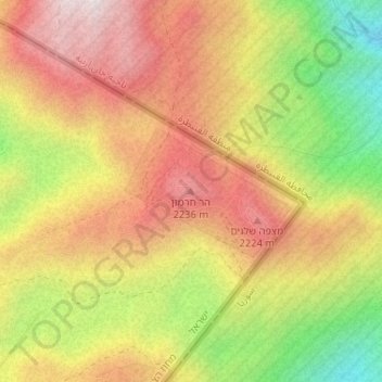
Name: 2236 Mt. Hermon topographic map, elevation, terrain.
Average elevation: 2,016 m
Minimum elevation: 1,611 m
Maximum elevation: 2,337 m
Other topographic maps
Click on a map to view its topography, its elevation and its terrain.
Avnay Eitan
Israel > North District > Golan Regional Council
Avnei Eitan (Hebrew: אַבְנֵי אֵיתָן) is an Israeli settlement organized as a moshav in the southern Golan Heights, located at an elevation of 385 meters (1,263 ft) above sea level. Located to the east of the Sea of Galilee, it falls under the municipal jurisdiction of Golan Regional Council. In…
Average elevation: 384 m