
Easthampstead topographic map
Interactive map
Click on the map to display elevation.
About this map
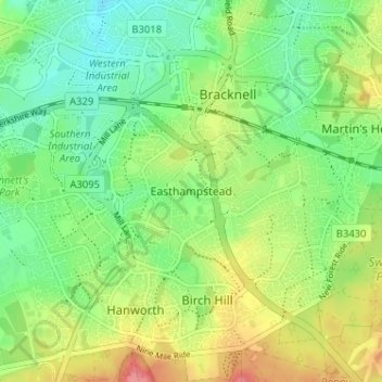
Name: Easthampstead topographic map, elevation, terrain.
Average elevation: 80 m
Minimum elevation: 50 m
Maximum elevation: 126 m
Other topographic maps
Click on a map to view its topography, its elevation and its terrain.
Wick Hill
United Kingdom > England > Bracknell Forest > Bracknell
Wick Hill, Bracknell, Bracknell Forest, England, RG42 2AD, United Kingdom
Average elevation: 68 m