
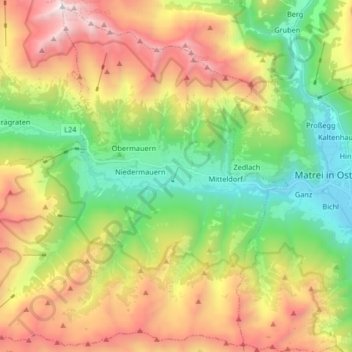
Virgen topographic map
Interactive map
Click on the map to display elevation.
About this map
Name: Virgen topographic map, elevation, terrain.
Location: Virgen, Bezirk Lienz, Tyrol, 9972, Austria (46.94518 12.34775 47.05380 12.51259)
Average elevation: 1,904 m
Minimum elevation: 928 m
Maximum elevation: 3,324 m
Virgen consists of seven subdivisions with seven hamlets. Starting from the East, going along the state highway, the first subdivision is Mitteldorf with the hamlet of Bach. Further along the road is the Virgen village subdivision, the main center of the municipality, with the hamlet of Weite. Northeast of Virgen center is the subdivision of Mellitz on the stream of the same name, and northwest on the Virgen stream is the subdivision of Göriach with the Marin hamlet. Göriach and Mellitz are however partially merged with Virgen center. West of the municipality center is the Obermauern subdivision on the Nillbach stream, and south of Obermauern is the Niedermauern subdivision with the Gries und Rain hamlet. The westernmost subdivision is Welzelach. In addition to the subdivisions and hamlets, there are also high altitude individual farms such as Sonnberg above Mellitz, east of Obermauern.
Other topographic maps
Click on a map to view its topography, its elevation and its terrain.
Jagdhausalm
Austria > Tyrol > Bezirk Lienz > Sankt Jakob in Defereggen
Jagdhausalm, Sankt Jakob in Defereggen, Bezirk Lienz, Tyrol, 9963, Austria
Average elevation: 2,371 m
Gemeinde Heinfels
Austria > Tyrol > Bezirk Lienz
Gemeinde Heinfels, Bezirk Lienz, Tyrol, 9919, Austria
Average elevation: 1,623 m
Kamelisenalm
Austria > Tyrol > Bezirk Lienz > Gemeinde Innervillgraten
Kamelisenalm, Gemeinde Innervillgraten, Bezirk Lienz, Tyrol, 9932, Austria
Average elevation: 2,092 m
Gemeinde Obertilliach
Austria > Tyrol > Bezirk Lienz
Gemeinde Obertilliach, Bezirk Lienz, Tyrol, 9942, Austria
Average elevation: 1,853 m
Gemeinde Ainet
Austria > Tyrol > Bezirk Lienz
Gemeinde Ainet, Bezirk Lienz, Tyrol, 9951, Austria
Average elevation: 1,843 m
Bobojach
Austria > Tyrol > Bezirk Lienz > Gemeinde Prägraten am Großvenediger
Bobojach, Gemeinde Prägraten am Großvenediger, Bezirk Lienz, Tyrol, 9974, Austria
Average elevation: 1,728 m
Salzbodensee
Austria > Tyrol > Bezirk Lienz > Marktgemeinde Matrei in Osttirol
Salzbodensee, Marktgemeinde Matrei in Osttirol, Bezirk Lienz, Tyrol, 9971, Austria
Average elevation: 2,250 m
Schlatenkees
Austria > Tyrol > Bezirk Lienz > Gemeinde Prägraten am Großvenediger
Schlatenkees, Gemeinde Prägraten am Großvenediger, Bezirk Lienz, Tyrol, Austria
Average elevation: 2,949 m
Lengberg
Austria > Tyrol > Bezirk Lienz > Gemeinde Nikolsdorf > Lengberg
Lengberg, Gemeinde Nikolsdorf, Bezirk Lienz, Tyrol, 9782, Austria
Average elevation: 961 m