
Elbe topographic map
Interactive map
Click on the map to display elevation.
Elbe
The Elbe rises at an elevation of about 1,400 metres (4,593 ft) in the Krkonoše (also known as Giant Mountains or in German as Riesengebirge) on the northwest borders of the Czech Republic near Labská bouda. Of the numerous small streams whose waters compose the infant river, the most important is the Bílé Labe, or White Elbe. After plunging down the 60 metres (197 ft) of the Labský vodopád, or Elbe Falls, the latter stream unites with the steeply torrential Malé Labe, and thereafter the united stream of the Elbe pursues a southerly course, emerging from the mountain glens at Jaroměř, where it receives Úpa and Metuje.
About this map
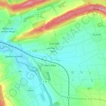
Name: Elbe topographic map, elevation, terrain.
Average elevation: 142 m
Minimum elevation: 105 m
Maximum elevation: 234 m
Other topographic maps
Click on a map to view its topography, its elevation and its terrain.
Werlaburgdorf
Germany > Lower Saxony > Landkreis Wolfenbüttel > Werlaburgdorf
Average elevation: 111 m