
Lenk topographic map
Interactive map
Click on the map to display elevation.
About this map
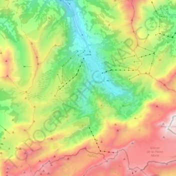
Name: Lenk topographic map, elevation, terrain.
Average elevation: 1,931 m
Minimum elevation: 1,009 m
Maximum elevation: 3,239 m
Other topographic maps
Click on a map to view its topography, its elevation and its terrain.
Jaunpass
Switzerland > Bern > Obersimmental-Saanen administrative district > Boltigen
Average elevation: 1,444 m
Stand
Switzerland > Bern > Obersimmental-Saanen administrative district > Saanen
Average elevation: 1,746 m
Sankt Stephan
Switzerland > Bern > Obersimmental-Saanen administrative district > St. Stephan > Sankt Stephan
Average elevation: 1,310 m
Saanen
Switzerland > Bern > Obersimmental-Saanen administrative district > Saanen > Saanen
Average elevation: 1,222 m