
Columbia City topographic map
Interactive map
Click on the map to display elevation.
About this map
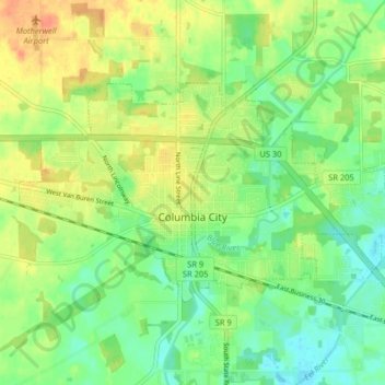
Name: Columbia City topographic map, elevation, terrain.
Location: Columbia City, Whitley County, Indiana, 46725, United States (41.14341 -85.52487 41.17806 -85.44416)
Average elevation: 261 m
Minimum elevation: 243 m
Maximum elevation: 283 m
Other topographic maps
Click on a map to view its topography, its elevation and its terrain.
Larwill
United States > Indiana > Whitley County
Larwill, Whitley County, Indiana, United States
Average elevation: 288 m
Columbia City
United States > Indiana > Whitley County > Columbia City > Columbia City
Columbia City, Whitley County, Indiana, 26725, United States
Average elevation: 260 m