
Gaggenau topographic map
Interactive map
Click on the map to display elevation.
About this map
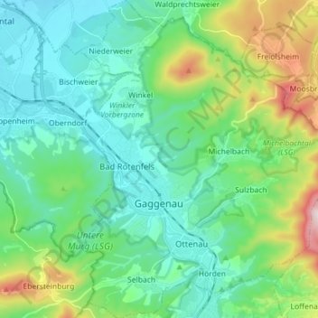
Name: Gaggenau topographic map, elevation, terrain.
Location: Gaggenau, Landkreis Rastatt, Baden-Württemberg, 76571, Germany (48.76934 8.28499 48.86263 8.41736)
Average elevation: 257 m
Minimum elevation: 115 m
Maximum elevation: 718 m
Other topographic maps
Click on a map to view its topography, its elevation and its terrain.
Bernhurst
Germany > Baden-Württemberg > Landkreis Rastatt > Muckenschopf
Bernhurst, Muckenschopf, Lichtenau, Verwaltungsverband Rheinmünster-Lichtenau, Landkreis Rastatt, Baden-Württemberg, 77839, Germany
Average elevation: 129 m
Sand
Germany > Baden-Württemberg > Landkreis Rastatt > Bühl
Sand, Bühl, Vereinbarte Verwaltungsgemeinschaft Bühl, Landkreis Rastatt, Baden-Württemberg, 77815, Germany
Average elevation: 805 m