
Rivière topographic map
Interactive map
Click on the map to display elevation.
About this map
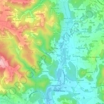
Name: Rivière topographic map, elevation, terrain.
Average elevation: 155 m
Minimum elevation: 89 m
Maximum elevation: 275 m
Other topographic maps
Click on a map to view its topography, its elevation and its terrain.
La Brame
France > Nouvelle-Aquitaine > Dordogne > Saint-Vincent-le-Paluel
La Brame, Saint-Vincent-le-Paluel, Sarlat-la-Canéda, Dordogne, Nouvelle-Aquitaine, France métropolitaine, 24200, France
Average elevation: 147 m