
Engolasters topographic map
Interactive map
Click on the map to display elevation.
About this map
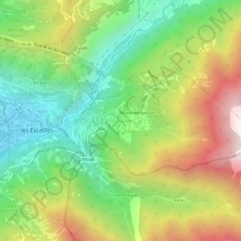
Name: Engolasters topographic map, elevation, terrain.
Location: Engolasters, Escaldes-Engordany, AD700, Andorra (42.49051 1.53923 42.53051 1.57923)
Average elevation: 1,592 m
Minimum elevation: 1,021 m
Maximum elevation: 2,418 m
Other topographic maps
Click on a map to view its topography, its elevation and its terrain.