
Crumlin topographic map
Interactive map
Click on the map to display elevation.
About this map
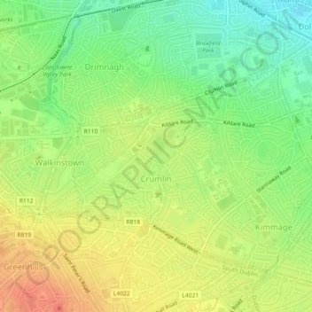
Name: Crumlin topographic map, elevation, terrain.
Average elevation: 43 m
Minimum elevation: 19 m
Maximum elevation: 66 m
Other topographic maps
Click on a map to view its topography, its elevation and its terrain.
Belcamp
Ireland > County Dublin > Dublin
Belcamp, Priorswood B ED, Dublin, County Dublin, Leinster, Ireland
Average elevation: 37 m
North Bull Island
Ireland > County Dublin > Dublin
North Bull Island, Raheny B ED, Dublin, County Dublin, Leinster, Ireland
Average elevation: 2 m