
Furnace topographic map
Interactive map
Click on the map to display elevation.
About this map
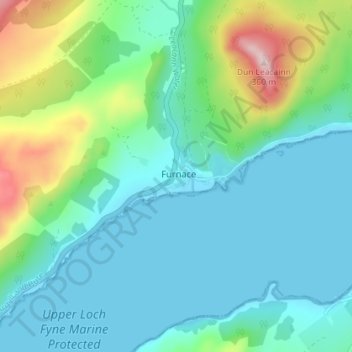
Name: Furnace topographic map, elevation, terrain.
Location: Furnace, Argyll and Bute, Scotland, PA32 8YP, United Kingdom (56.13230 -5.20417 56.17230 -5.16417)
Average elevation: 79 m
Minimum elevation: -2 m
Maximum elevation: 357 m
Other topographic maps
Click on a map to view its topography, its elevation and its terrain.
Loch Sidheannach
United Kingdom > Scotland > Furnace
Loch Sidheannach, Leacainn Forest Drive, Furnace, Argyll and Bute, Scotland, PA33 1BU, United Kingdom
Average elevation: 339 m