
Athens topographic map
Interactive map
Click on the map to display elevation.
About this map
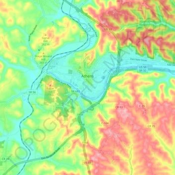
Name: Athens topographic map, elevation, terrain.
Location: Athens, Athens County, Ohio, 45701, United States (39.28631 -82.14276 39.36030 -82.03287)
Average elevation: 240 m
Minimum elevation: 184 m
Maximum elevation: 308 m
Other topographic maps
Click on a map to view its topography, its elevation and its terrain.
Middle Branch Shade River
United States > Ohio > Athens County
Middle Branch Shade River, Athens County, Ohio, 45720, United States
Average elevation: 245 m
Millfield
United States > Ohio > Athens County > Millfield
Millfield, Athens County, Ohio, 45761, United States
Average elevation: 237 m
Glouster
United States > Ohio > Athens County
Glouster, Athens County, Ohio, United States
Average elevation: 235 m