
Dundas Parish topographic map
Interactive map
Click on the map to display elevation.
About this map
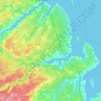
Name: Dundas Parish topographic map, elevation, terrain.
Location: Dundas Parish, Kent County, New Brunswick, Canada (46.27068 -64.87877 46.42285 -64.50963)
Average elevation: 31 m
Minimum elevation: -5 m
Maximum elevation: 129 m
Other topographic maps
Click on a map to view its topography, its elevation and its terrain.
Saint John
Canada > New Brunswick > Saint John
The topography surrounding Saint John is hilly; a result of the influence of two coastal mountain ranges which run along the Bay of Fundy – the St. Croix Highlands and the Caledonia Highlands. The soil throughout the region is extremely rocky with frequent granite outcrops. The coastal plain hosts numerous…
Average elevation: 44 m