
Houlgate topographic map
Interactive map
Click on the map to display elevation.
Houlgate
On September 6, 1912, early French aviator Roland Garros took off from the beach of Houlgate to break the world altitude record. Houlgate named their promenade after Garros in celebration of the town being the location where Garros broke the altitude record.
About this map
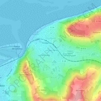
Name: Houlgate topographic map, elevation, terrain.
Average elevation: 36 m
Minimum elevation: -1 m
Maximum elevation: 134 m
Other topographic maps
Click on a map to view its topography, its elevation and its terrain.
Saint-Martin-de-Fontenay
France > Normandy > Calvados > Saint-Martin-de-Fontenay > Saint-Martin-de-Fontenay
Average elevation: 48 m