
Bronte topographic map
Interactive map
Click on the map to display elevation.
About this map
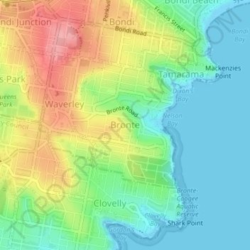
Name: Bronte topographic map, elevation, terrain.
Average elevation: 42 m
Minimum elevation: 0 m
Maximum elevation: 113 m
Other topographic maps
Click on a map to view its topography, its elevation and its terrain.
Randwick
Australia > New South Wales > Sydney > Bay Gardens
Randwick, Bay Gardens, Sydney, Randwick City Council, New South Wales, 2031, Australia
Average elevation: 44 m
Malabar Headland National Park
Australia > New South Wales > Sydney > Bay Gardens
Malabar Headland National Park, Malabar Headland Walking Path, Malabar, Bay Gardens, Sydney, Randwick City Council, New South Wales, 2036, Australia
Average elevation: 22 m