
Gampola topographic map
Interactive map
Click on the map to display elevation.
About this map
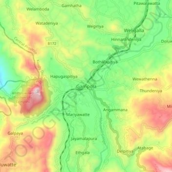
Name: Gampola topographic map, elevation, terrain.
Location: Gampola, Kandy District, Central Province, 20500, Sri Lanka (7.12365 80.53027 7.20365 80.61027)
Average elevation: 604 m
Minimum elevation: 284 m
Maximum elevation: 1,057 m
Other topographic maps
Click on a map to view its topography, its elevation and its terrain.
Horton Plains National Park
Horton Plains National Park (Sinhala: හෝර්ටන් තැන්න ජාතික උද්යානය, romanized: Hortan Thanna Jathika Udyanaya) is a national park in the central highlands of Sri Lanka that was designated in 1988. It covers an area of 31km² and borders Thotupalakanda Nature…
Average elevation: 2,010 m
Horton Plains National Park
Horton Plains National Park (Sinhala: හෝර්ටන් තැන්න ජාතික උද්යානය, romanized: Hortan Thanna Jathika Udyanaya) is a national park in the central highlands of Sri Lanka that was designated in 1988. It is located at an elevation of 2,100–2,300 m (6,900–7,500…
Average elevation: 2,010 m