
Gjirokastra topographic map
Interactive map
Click on the map to display elevation.
About this map
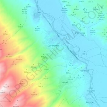
Name: Gjirokastra topographic map, elevation, terrain.
Average elevation: 519 m
Minimum elevation: 183 m
Maximum elevation: 1,584 m
Other topographic maps
Click on a map to view its topography, its elevation and its terrain.
Gjirokastër Castle
Albania > Southern Albania > Gjirokastër County > Gjirokastra
Average elevation: 333 m