
Middleton in Teesdale topographic map
Interactive map
Click on the map to display elevation.
About this map
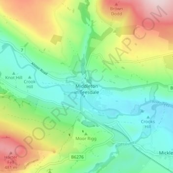
Name: Middleton in Teesdale topographic map, elevation, terrain.
Average elevation: 310 m
Minimum elevation: 203 m
Maximum elevation: 514 m
Other topographic maps
Click on a map to view its topography, its elevation and its terrain.
Aukside Plantation
United Kingdom > England > Middleton in Teesdale > Auk Side
Aukside Plantation, Auk Side, Middleton in Teesdale, County Durham, North East England, England, United Kingdom
Average elevation: 319 m