
Lostwithiel topographic map
Interactive map
Click on the map to display elevation.
About this map
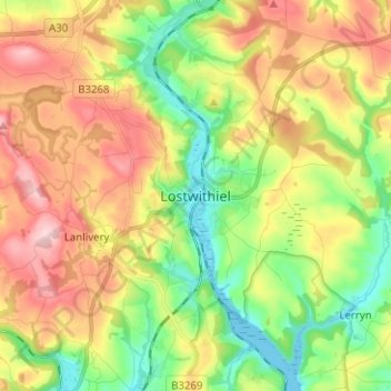
Name: Lostwithiel topographic map, elevation, terrain.
Average elevation: 94 m
Minimum elevation: -2 m
Maximum elevation: 211 m
Other topographic maps
Click on a map to view its topography, its elevation and its terrain.
Restormel Castle
United Kingdom > England > Lostwithiel
Restormel Castle, Restormel Road, Lostwithiel, Cornwall, South West England, England, PL22, United Kingdom
Average elevation: 79 m