
Ellicott City topographic map
Interactive map
Click on the map to display elevation.
About this map
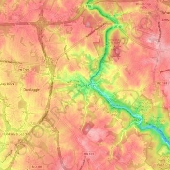
Name: Ellicott City topographic map, elevation, terrain.
Location: Ellicott City, Howard County, Maryland, 21043, United States (39.22733 -76.83831 39.30733 -76.75831)
Average elevation: 119 m
Minimum elevation: 16 m
Maximum elevation: 170 m
Other topographic maps
Click on a map to view its topography, its elevation and its terrain.
Columbia
United States > Maryland > Howard County > Columbia
The primary landforms in Columbia are rolling hills and stream valleys; Columbia's road network is laid out to follow the terrain, with many winding streets and cul-de-sacs. Elevations range from about 200 to 500 feet (61 to 152 m) above sea level. Most of Columbia is drained by the Middle Patuxent and Little…
Average elevation: 113 m
Patapsco Valley State Park
United States > Maryland > Howard County > Ilchester
Average elevation: 131 m