
Lustleigh topographic map
Interactive map
Click on the map to display elevation.
About this map
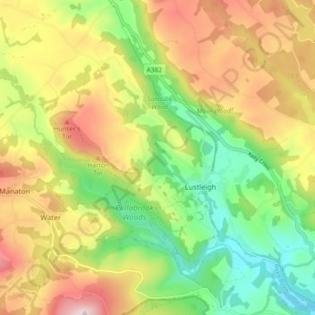
Name: Lustleigh topographic map, elevation, terrain.
Location: Lustleigh, Teignbridge, Devon, England, United Kingdom (50.59689 -3.77327 50.64880 -3.69768)
Average elevation: 204 m
Minimum elevation: 38 m
Maximum elevation: 404 m
Devon trails, hiking, mountain biking, running and outdoor activities
Other topographic maps
Click on a map to view its topography, its elevation and its terrain.
Southbrook
United Kingdom > England > Devon > Teignbridge > Buckland in the Moor
Average elevation: 239 m
Ponsworthy
United Kingdom > England > Devon > Teignbridge > Widecombe in the Moor
Average elevation: 278 m
Teignmouth Beach
United Kingdom > England > Devon > Teignbridge > Teignmouth > Shaldon
Average elevation: 24 m
Greatoak Cross
United Kingdom > England > Devon > Teignbridge > Abbotskerswell > Whiddon
Average elevation: 58 m
Haytor Rocks
United Kingdom > England > Devon > Teignbridge > Haytor Vale > Smallacombe
Average elevation: 354 m
Holcombe Down
United Kingdom > England > Devon > Teignbridge > Teignmouth > Holcombe Down
Average elevation: 101 m
Bonehill
United Kingdom > England > Devon > Teignbridge > Widecombe in the Moor > Bonehill
Average elevation: 354 m