
Cherokee Park topographic map
Interactive map
Click on the map to display elevation.
About this map
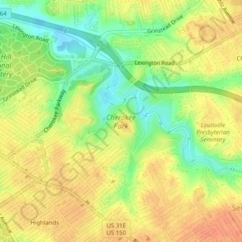
Name: Cherokee Park topographic map, elevation, terrain.
Average elevation: 159 m
Minimum elevation: 134 m
Maximum elevation: 175 m
Other topographic maps
Click on a map to view its topography, its elevation and its terrain.
Shawneeland
United States > Kentucky > Jefferson County > Louisville
Shawneeland, Louisville, Jefferson County, Kentucky, 40211, United States
Average elevation: 138 m
Waverly Hills
United States > Kentucky > Jefferson County > Louisville
Waverly Hills, Louisville, Jefferson County, Kentucky, 40258, United States
Average elevation: 155 m
Parkland
United States > Kentucky > Jefferson County > Louisville
Parkland, Louisville, Jefferson County, Kentucky, 40211, United States
Average elevation: 139 m
Saint Matthews
United States > Kentucky > Jefferson County > Louisville
Saint Matthews, Louisville, Jefferson County, Kentucky, 40207, United States
Average elevation: 166 m
Cherokee Garden
United States > Kentucky > Jefferson County > Louisville
Cherokee Garden, Louisville, Jefferson County, Kentucky, 40041, United States
Average elevation: 164 m
Newburg
United States > Kentucky > Jefferson County > Louisville
Newburg, Louisville, Jefferson County, Kentucky, 40225, United States
Average elevation: 156 m
Louisville-Jefferson County (Balance)
United States > Kentucky > Jefferson County > Louisville
Louisville-Jefferson County (Balance), Louisville, Jefferson County, Kentucky, 40231, United States
Average elevation: 157 m
South Park
United States > Kentucky > Jefferson County > Louisville
South Park, Louisville, Jefferson County, Kentucky, 40118, United States
Average elevation: 149 m
Mirror Lakes
United States > Kentucky > Jefferson County > Louisville > Hopewell
Mirror Lakes, Hopewell, Louisville, Jefferson County, Kentucky, United States
Average elevation: 198 m
Falls of the Ohio State Park
United States > Kentucky > Jefferson County > Louisville
Falls of the Ohio State Park, Louisville, Jefferson County, Kentucky, United States
Average elevation: 135 m
Fern Creek
United States > Kentucky > Jefferson County > Louisville
Fern Creek, Louisville, Jefferson County, Kentucky, 40291, United States
Average elevation: 211 m
Bethany
United States > Kentucky > Jefferson County > Louisville
Bethany, Louisville, Jefferson County, Kentucky, 40272, United States
Average elevation: 141 m
Fairdale
United States > Kentucky > Jefferson County > Louisville
Fairdale, Louisville, Jefferson County, Kentucky, 40118, United States
Average elevation: 158 m