
Neuburg an der Donau topographic map
Interactive map
Click on the map to display elevation.
About this map
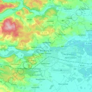
Name: Neuburg an der Donau topographic map, elevation, terrain.
Average elevation: 413 m
Minimum elevation: 367 m
Maximum elevation: 566 m
Other topographic maps
Click on a map to view its topography, its elevation and its terrain.
Brunnen
Germany > Bavaria > Landkreis Neuburg-Schrobenhausen
Brunnen, Schrobenhausen, Landkreis Neuburg-Schrobenhausen, Bavaria, 86564, Germany
Average elevation: 399 m
Zell
Germany > Bavaria > Landkreis Neuburg-Schrobenhausen > Neuburg an der Donau
Zell, Neuburg an der Donau, Landkreis Neuburg-Schrobenhausen, Bavaria, 86633, Germany
Average elevation: 379 m
Rennertshofen
Germany > Bavaria > Landkreis Neuburg-Schrobenhausen
Rennertshofen, Landkreis Neuburg-Schrobenhausen, Bavaria, 86643, Germany
Average elevation: 451 m