
Woodstock topographic map
Interactive map
Click on the map to display elevation.
About this map
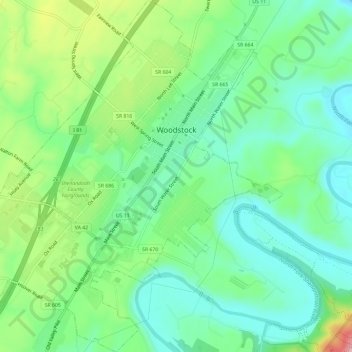
Name: Woodstock topographic map, elevation, terrain.
Location: Woodstock, Shenandoah County, Virginia, United States (38.85281 -78.54297 38.89864 -78.48794)
Average elevation: 252 m
Minimum elevation: 195 m
Maximum elevation: 380 m
Other topographic maps
Click on a map to view its topography, its elevation and its terrain.
Mount Jackson
United States > Virginia > Shenandoah County
Mount Jackson, Shenandoah County, Virginia, United States
Average elevation: 306 m
New Market
United States > Virginia > Shenandoah County
New Market, Shenandoah County, Virginia, 22844, United States
Average elevation: 310 m
Strasburg
United States > Virginia > Shenandoah County
Strasburg, Shenandoah County, Virginia, United States
Average elevation: 195 m
Bonnet Hill
United States > Virginia > Shenandoah County
Bonnet Hill, Shenandoah County, Virginia, United States
Average elevation: 391 m