
Rusizi topographic map
Interactive map
Click on the map to display elevation.
About this map
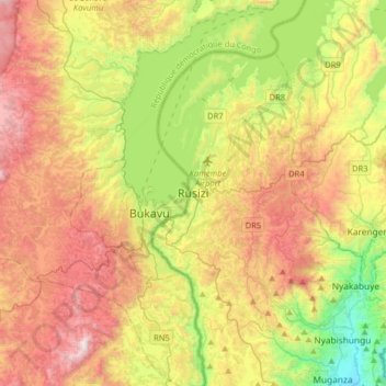
Name: Rusizi topographic map, elevation, terrain.
Location: Rusizi, Kamembe, Rusizi, Western Province, Rwanda (-2.64878 28.73581 -2.32878 29.05581)
Average elevation: 1,684 m
Minimum elevation: 985 m
Maximum elevation: 2,525 m
Other topographic maps
Click on a map to view its topography, its elevation and its terrain.
Kamembe
Rwanda > Western Province > Rusizi > Kamembe
Kamembe, Rusizi, Western Province, Rwanda
Average elevation: 1,611 m