
Kusa topographic map
Interactive map
Click on the map to display elevation.
About this map
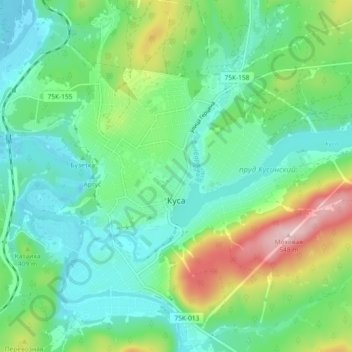
Name: Kusa topographic map, elevation, terrain.
Average elevation: 379 m
Minimum elevation: 312 m
Maximum elevation: 550 m
Other topographic maps
Click on a map to view its topography, its elevation and its terrain.
Kusa
Russia > Chelyabinsk Oblast > Kusinsky District > Kusa
Kusa, Кусинское городское поселение, Kusinsky District, Chelyabinsk Oblast, Ural Federal District, 456940, Russia
Average elevation: 400 m