
Jamshoro topographic map
Interactive map
Click on the map to display elevation.
About this map
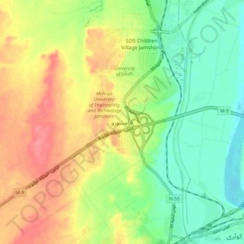
Name: Jamshoro topographic map, elevation, terrain.
Location: Jamshoro, Sindh, Pakistan (25.36072 68.22617 25.44072 68.30617)
Average elevation: 42 m
Minimum elevation: 10 m
Maximum elevation: 80 m
Other topographic maps
Click on a map to view its topography, its elevation and its terrain.
Nooriabad
Pakistan > Sindh > Jamshoro District
Nooriabad, Thana Bulla Khan Taluka, Jamshoro District, Sindh, 71503, Pakistan
Average elevation: 149 m