
Amersfoort topographic map
Interactive map
Click on the map to display elevation.
About this map
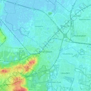
Name: Amersfoort topographic map, elevation, terrain.
Location: Amersfoort, Utrecht, Netherlands (52.10838 5.30646 52.21915 5.47992)
Average elevation: 7 m
Minimum elevation: -3 m
Maximum elevation: 52 m
The construction of the tower and the church was started in 1444. The church was destroyed by an explosion in 1787, but the tower survived, and the layout of the church still can be discerned today through the use of different types of stone in the pavement of the open space that was created. It is now the reference point of the RD coordinate system, the coordinate grid used by the Dutch topographical service: the RD coordinates are (155.000, 463.000).
Other topographic maps
Click on a map to view its topography, its elevation and its terrain.
Wijk bij Duurstede
Netherlands > Utrecht > Wijk bij Duurstede
Wijk bij Duurstede, Utrecht, Netherlands
Average elevation: 5 m
Nieuwer Ter Aa
Nieuwer Ter Aa, Stichtse Vecht, Utrecht, Netherlands
Average elevation: -1 m
Hoogland
Netherlands > Utrecht > Amersfoort
Hoogland, Amersfoort, Utrecht, Netherlands
Average elevation: 2 m
Eembrugge
Netherlands > Utrecht > Baarn
Eembrugge, Baarn, Utrecht, Netherlands, 3741 LB, Netherlands
Average elevation: 1 m
Maarsbergen
Maarsbergen, Utrechtse Heuvelrug, Utrecht, Netherlands
Average elevation: 13 m
Bunschoten-Spakenburg
Bunschoten-Spakenburg, Bunschoten, Utrecht, Netherlands
Average elevation: 0 m
Waterschap Amstel, Gooi en Vecht
Waterschap Amstel, Gooi en Vecht, Utrecht, Netherlands
Average elevation: 0 m
Utrechtse Heuvelrug
Utrechtse Heuvelrug, Utrecht, Netherlands
Average elevation: 10 m
Overberg
Overberg, Utrechtse Heuvelrug, Utrecht, Netherlands
Average elevation: 17 m
Leersum
Leersum, Utrechtse Heuvelrug, Utrecht, Netherlands
Average elevation: 15 m
Amerongen
Amerongen, Utrechtse Heuvelrug, Utrecht, Netherlands
Average elevation: 15 m
Soesterberg
Netherlands > Utrecht > Soest
Soesterberg, Soest, Utrecht, Netherlands
Average elevation: 18 m
Cabauw
Cabauw, Lopik, Utrecht, Netherlands, 3411 ED, Netherlands
Average elevation: -1 m
Kromme Rijn
Netherlands > Utrecht > Wijk bij Duurstede
Kromme Rijn, Wijk bij Duurstede, Utrecht, Netherlands, 3945BN, Netherlands
Average elevation: 5 m
De Ronde Venen
Netherlands > Utrecht > De Ronde Venen
De Ronde Venen, Utrecht, Netherlands
Average elevation: -2 m
Mijdrecht
Mijdrecht, De Ronde Venen, Utrecht, Netherlands
Average elevation: -4 m