
Ganja topographic map
Interactive map
Click on the map to display elevation.
About this map
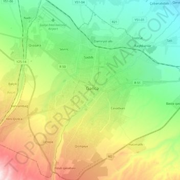
Name: Ganja topographic map, elevation, terrain.
Location: Ganja, Ganja-Dashkasan, Azerbaijan (40.60268 46.25322 40.75361 46.44194)
Average elevation: 430 m
Minimum elevation: 237 m
Maximum elevation: 796 m
Other topographic maps
Click on a map to view its topography, its elevation and its terrain.
Goygol District
Goygol District, Ganja-Dashkasan, 2500, Azerbaijan
Average elevation: 1,197 m
Mingachevir Reservoir
Mingachevir Reservoir, Samukh District, Ganja-Dashkasan, Azerbaijan
Average elevation: 175 m
Ganja City
Ganja City, Ganja-Dashkasan, Azerbaijan
Average elevation: 440 m